STATE OF WASHINGTON
DEPARTMENT OF NATURAL RESOURCES
BERT L. COLE, Commissioner of Public Lands
DON LEE FRASER, Supervisor
DIVISION OF GEOLOGY AND EARTH RESOURCES
VAUGHN E. LIVINGSTON JR., State Geologist
INFORMATION CIRCULAR 52
LANDSLIDES IN SEATTLE
By
DONALD W. TUBBS
Prepared in cooperation with
UNITED STATES GEOLOGICAL SURVEY
1974
FOREWORD
Landslides are a major natural hazard in the Seattle area. Every year land movements occur in residential areas that may not be large enough to warrant news coverage but can amount to personal disaster to the landowners on whose property they occur.
Basically it can be said that
landslides are caused by one or a combination of two or more of the
following factors: (a) change in slope gradient, (b) increasing the
load that the land must bear, (c) shocks and vibrations, (d) change
in water content, (e) ground-water movement, (f) frost action or
wedging, (g) weathering of rocks, and (h) removal or changing the
type of vegetation covering slopes. Of these factors, five (a, b, c,
d, and h) can be man-related. In an attempt to identify the reasons
for landsliding in the Seattle area, the Division of Geology and
Earth Resources, in cooperation with the U.S. Geological Survey,
began studying the landslides in the spring of 1972. Donald W. Tubbs,
a graduate student at the University of Washington who was interested
in landslides, was selected to do the job. Mr. Tubbs made a thorough
search of city records and interviewed many people in the Seattle
area in order to arrive at damage estimates. He also examined many of
the slides in an attempt to identify the geologic, climatic, and
human factors that were responsible for the slides.
Vaughn E. Livingston, Jr.
Washington State Geologist
Division of Geology and Earth Resources
Olympia, WA 98504
October 1, 1974
LANDSLIDES IN SEATTLE
By
DONALD W. TUBBS
ABSTRACT
During early 1972 an unusually large number of landslides occurred in the Seattle area, causing hundreds of thousands of dollars in damages to public and private property. The slides were the result of identifiable geologic, climatic, and human factors. These conditions are discussed in the hope that this information will be useful to planners and private citizens seeking to minimize future landslide damage by avoiding or accommodating to similar conditions where possible.
Several climatic factors were involved:
1. The early part of 1972 had greater than normal rainfall, and consequently the water table was high.
2. A cold spell in late January and early February may have given the soil a high infiltration capacity.
3. During late February and early March several days of unusually intense rainfall occurred, which triggered most of the slides.
The geologic conditions that determined the locations of the landslides are directly related to the glacial history of the Seattle area. The slides usually involved surficial material overlying more impermeable deposits. A zone of considerable landslide hazard exists along the trace of the contact between the Esperance Sand and either the Lawton Clay or pre-Lawton sediments.
Human activities were a
contributing factor in producing many of the slides. The most common
human factors were the diversion of drainage water onto the slopes,
hillside excavation, and the placing of artificial fill over
impermeable deposits. A few slides involved failure of retaining walls.
INTRODUCTION
During the early part of 1972,
the Puget Sound area suffered numerous landslides, which resulted in
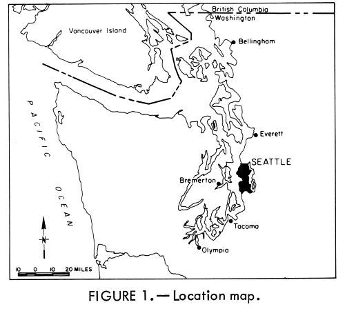
damages totaling millions of dollars. The Seattle area (Fig. 1) was
particularly hard hit, owing partly to extensive urbanization and
partly to geologic factors. The geologic and climatic conditions
under which most of the landslides occurred were remarkably
consistent. The geologic factors persist and similar weather
conditions will recur. Thus, the probability of future periods of
intense landsliding in Seattle is quite high.
This report describes the conditions under which landslides occurred in Seattle during early 1972 and draws inferences about the most likely times and places of future landsliding. It is hoped that the delineation of hazardous areas will be useful in land use planning. This information should also alert individuals considering construction in potentially hazardous areas to the advisability of consulting a geologist or soils engineer.
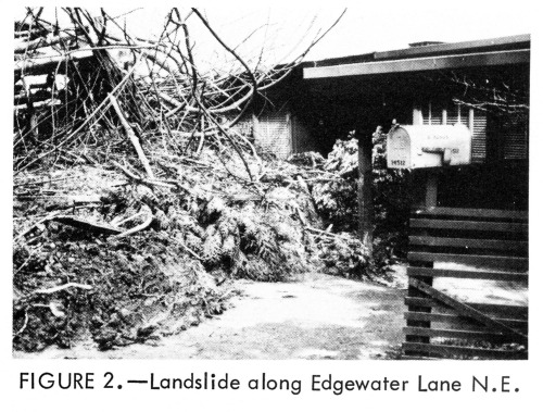
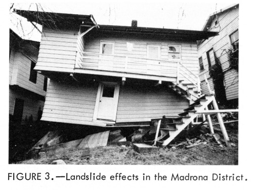
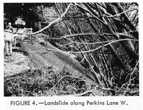
Fifty landslides were studied for this report. They caused a total of nearly $500,000 in damages, of which approximately 60 percent occurred to public property and about 40 percent to private property. This damage estimate should be considered a minimum amount, representing only those damages that can be readily expressed in monetary terms, and including only those slides shown on Plate 1. A few other significant landslides are known to have occurred, and there were undoubtedly some slides of which the author is unaware. Also, the above figures do not include the many small slides that occur annually and which are considered as normal maintenance problems by both the city and private landowners.
The periods of greatest landslide activity coincided with storms that also caused flood damage in Seattle (see Climatic Causes). Since maintenance crews were hard pressed to solve the various storm-related problems in the city, attention to landslide effects delayed the other emergency maintenance operations.
To the residents and property owners affected, the slides represented more than a specific economic loss. They were also the cause of considerable anxiety and inconvenience; the slides demanded attention and decisions which consumed a great deal of time and energy.
Such items as traffic delays and
personal inconvenience cannot be as easily measured as the costs of
engineering studies, reconstruction, and preventive measures, and
thus are excluded from the previously stated estimate. Nevertheless,
such indirect costs are a significant portion of the total impact of
the landslides.
SOURCES OF INFORMATION
Because of extensive flooding and landsliding in western Washington during early 1972, the President designated a large part of the Puget Sound lowland as a natural disaster area. This action made Federal disaster assistance available and encouraged both public and private property owners to apply for funds to aid reconstruction. Federal funds compensated for much of the economic loss due to the slides, and the resulting disaster assistance records include information on the location and the amount of damage due to landslides during this period. Both the Office of Emergency Preparedness and the Small Business Administration generously provided information from those records for the purposes of this study.
Information was provided by the Engineering Department of the City of Seattle on the location of landslides which affected city property. Also, news accounts in the Seattle Times were reviewed for the period January through April, 1972. These latter two sources largely repeated information available from the Federal records.
This report deals only with those landslides included in the Federal disaster records. This restriction has the advantage of making the information on damages due to slides more readily comparable to information from surrounding areas, where newspaper and engineering records are less complete. The restriction excludes only a small number of known slides, and does not seriously affect the conclusions of the report.
Each of the landslides included
in the Federal disaster assistance records was examined in the field
to verify the location and to assess the causes of sliding. The
author extends thanks to the many individual property owners who
supplied firsthand descriptions of the landslides, and who granted
access to their property for geologic reconnaissance.
CAUSES OF THE LANDSLIDES
There is probably no such thing
as a single cause of a landslide. A number of conditions usually
interact to make a rock or soil mass susceptible to sliding, although
commonly a single factor can be identified as finally triggering the
movement. In the Seattle area, geologic events resulted in a
particular set of deposits and landforms. It was the interaction
between these geologic conditions and certain climatic conditions,
and in some cases also human activities, that produced the landslides
of early 1972.
GENERAL CAUSES
Gravity is the driving force of landsliding, but its effectiveness in producing landslides depends on certain other factors. One such factor is the type of material involved. The landslides in the Seattle area generally occurred in unconsolidated or partially consolidated sediments. Although most of these sediments have been overridden and compacted by several thousand feet of glacial ice, they are not "solid rock."
Another factor controlling the
effect of gravity in causing landslides is topography. Most of the
present landforms in the Seattle area are at least in part the
product of the last glaciation. The relatively steep slopes
surrounding many of the upland areas were left in an unstable
condition when the ice receded. This instability has been increased
in some places by wave and current erosion along the base of the slope.
CLIMATIC CAUSES
The previous generalizations apply to many parts of the Seattle area and persist from year to year. However, during the early part of 1972 three climatic conditions combined to produce a period of particularly intense landsliding.
1. The general period was considerably wetter than normal, with the months of February, March, and April receiving about 40 percent more precipitation than usual (Fig. 5).
2. A cold spell in late January and early February probably resulted in a high infiltration capacity (the rate at which soil can absorb water), due to the loosening of the soil structure by the growth and subsequent melting of ice crystals within the soil.
3. Several days of unusually intense rainfall occurred during late February and early March.
Daily precipitation is
illustrated in Figure 6, along with a plot of the frequency of
landslides. The exact date of occurrence is known for only 30 of the
50 landslides examined during this study. As shown, over 70 percent
of those slides occurred on one of the two days in late February and
early March during which more than 1.75 inches of rain fell in a
24-hour period. Nearly 90 percent of the slides occurred on one of
the three days in the same period that received more than an inch of rain.
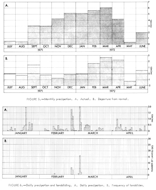
The abundant precipitation during this general period, aided by the inferred high infiltration capacity of the soil, is believed to have resulted in an unusually high water table. The days of intense rainfall then produced widespread saturation of surficial material, as the water could not rapidly seep into the already soggy ground; also, the high water table and the intense rainfall caused the development of locally high water pressure in certain stratigraphic units. These effects will be discussed in the next section.
Both a generally high water table
and an interval of intense rainfall appear necessary to produce a
period of high landslide incidence. This conclusion is supported by
the lack of continued landsliding in late March and early April, when
monthly precipitation and presumably the water table were both higher
than normal, but when there were no days of extremely intense
rainfall. It is also supported by the fact that widespread
landsliding did not occur in Seattle on January 20th, when nearly two
inches of rain fell following several months of average or slightly
below average precipitation.
GEOLOGIC CAUSES
An understanding of the geologic causes of the landslides requires some knowledge of the geology of the Seattle area. For those unacquainted with the stratigraphic units mentioned in this section of the report, a brief summary of the geologic history of the Seattle area will be found in Geologic Background. Although a general appreciation of the geologic causes can be obtained from the following discussion without benefit of any background knowledge of geology, the information contained in Geologic Background is necessary for thorough understanding and useful application of the relationships discussed.
The landslides generally occurred where surficial debris (including slope wash, artificial fill, and vegetational debris) rested on relatively impermeable deposits such as the Vashon till, the Lawton Clay, and much of the pre-Lawton (older) material. Slope debris lying atop such poorly permeable materials can readily become saturated during heavy rains, because the water cannot seep rapidly into the underlying material. When surficial debris on a hillslope becomes saturated, seepage forces acting within the mass reduce the stability of the material. If the material had previously been in a condition of marginal stability, it may slide.
In a few instances, landslides resulted from conditions that were effectively the reverse of the situation outlined above. Where clay-rich, poorly permeable material overlies beds of more permeable material, pressure may build up beneath the relatively impermeable cap until a portion of the weight of the debris is being supported by the fluid pressure. This significantly reduces the resistance to sliding of the overlying debris, thereby decreasing stability. The mechanism is most applicable to slope debris overlying pre-Lawton sediments, which in many places are quite heterogeneous. Some beds within these sediments produce fine-grained slope wash that may cover other, more permeable beds. This mechanism may also be a factor in a few of the slides involving Vashon till.
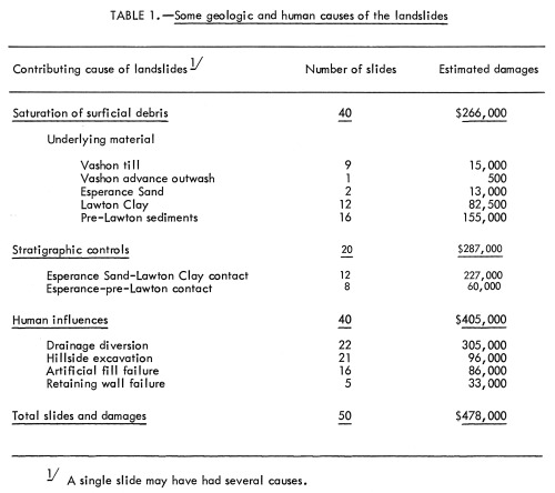
Table 1 shows the influence of these mechanisms quite clearly. Of the 50 landslides studied, saturation of surficial debris was a cause (although not necessarily the only cause) of 40 slides. In 37 of those slides, the underlying material was either Vashon till, Lawton Clay, or pre-Lawton sediments. This information is not surprising and, unfortunately, not particularly useful for planning purposes. The area underlain by these materials includes most of the city; to be most useful, geologic identification of slide-prone sites should be more specific.
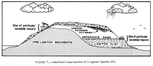
More specific areas of high
landslide hazard can be delineated by relating the positions of the
studied slides to certain stratigraphic contracts. For instance, the
landslides that involved saturation of debris atop the Lawton Clay
generally occurred along the trace of the Esperance Sand-Lawton Clay
contact (Fig. 7). To understand why, it is only necessary to consider
the effect of that contact on the movement of ground water. Water can
readily move down through the Esperance Sand until it reaches the top
of the Lawton Clay. At that horizon its downward movement is halted,
or greatly slowed, and the water moves laterally until it intersects
a hillside. Therefore, along the trace of the contact between the
Esperance Sand and the Lawton Clay there is often much seepage, which
contributes to the saturation of debris resting upon the Lawton Clay
(Mackin, 1949).
The upper part of the Lawton Clay includes alternating sand and clay layers. These sand-clay interbeds have some importance in the mechanics of a number of the larger landslides, but it is beyond the scope of this paper to consider the details of their role. Briefly, it appears that the sand beds are often the planes along which much of the initial movement takes place; this may be due to the development of water pressure in the pore space between the sand particles, which decreases the shear strength of the sand.
Where the Esperance Sand directly overlies pre-Lawton sediments, seepage and landslides are also common as a result of the same sort of ground-water conditions described above. Since no widespread zone of interbedded sand and clay is present along the Esperance-pre-Lawton contact, landslide mechanisms dependent on such sand-clay interbeds are not of general concern there. On the other hand, weathering of the upper part of the pre-Lawton material during the Olympia Interglaciation produced clays with undesirable engineering properties (Mullineaux and others, 1964). Also, within the pre-Lawton sediments there are interbeds of sand and clay and other zones of higher than average landslide hazard; however, these are often discontinuous and are too poorly exposed to be delineated in this report. The extent to which other aspects of the pre-Lawton material are localizing factors in the landslides remains to be determined.
The Esperance Sand-Lawton Clay contact and the Esperance-pre-Lawton contact apparently influence the location of landslides even where the contacts are obscured by Vashon till. Several of the slides in surficial debris overlying Vashon till were near the inferred local elevation of one of these contacts. Water from behind the till could be a cause of such slides either by its contribution to the saturation of the overlying debris or by the development of fluid pressure beneath the poorly permeable till cap. The former interpretation is preferred because most of these slides apparently involved only the loose surficial debris. Had slope failure been due to the "capping effect" of the till, the till itself should have been more generally involved, since it is in this relatively impermeable material that the greatest pressure gradients would have developed. However, it may be that both mechanisms are operative in places.
Considering the roles of the Esperance Sand-Lawton Clay contact and the Esperance-pre-Lawton contact in localizing landslide activity, it is possible to delineate a relatively narrow zone of particular landslide hazard near the base of the Esperance Sand. This zone, shown on Plate 1, was drawn on the basis of existing geologic maps and geologic reconnaissance conducted as part of this study. Landslides originating along the trace of the relevant contacts can affect areas both upslope and downslope from the line of origin. For drafting reasons, the hazardous zone is shown on Plate 1 as having finite width, but the hazard progressively decreases to either side of the trace and in some places extends beyond the boundaries shown. Because of the scale of geologic mapping in this area, the contacts shown on the maps (and thus the zone depicted in Plate 1) may locally be misplaced by several tens or even hundreds of feet. Thus, in using Plate 1 to make planning decisions concerning individual sites along the delineated zone, it is essential to field-check the sites to determine the actual location of the hazardous zone on the basis of the relationships previously discussed.
Twenty landslides, 40 percent of
the total number studied, occurred along the delineated zone.
However, since these slides were on the average larger and more
destructive than those not related to stratigraphic controls, this
zone accounted for about 60 percent of the total damage.
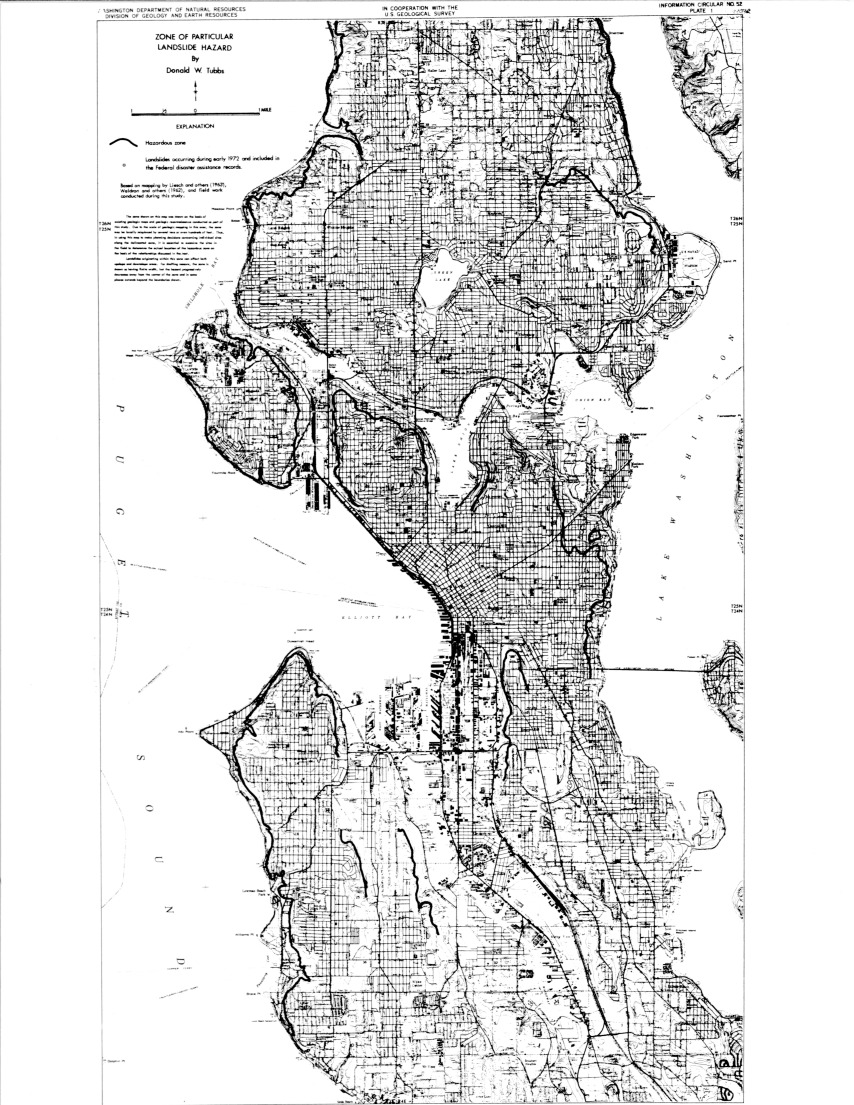
Plate 1. Zone of particular landslide hazard
(Click on map to enlarge.)
HUMAN CAUSES
Considerable landslide modification accompanies urbanization, and was a contributing factor in many of the landslides. In fact, 80 percent of the landslides involved one or more of the human causes listed in Table 1.
Diversion of excess water onto the slope was one of the most common human influences, contributing to well over 40 percent of the landslides. The water most often came from roofs and paved areas, but sewers, water lines, culverts, ponds, and ditches were also sources.
Hillside excavations, primarily roadcuts, but also those due to landscaping and construction activities, were a factor in more than 40 percent of the landslides. In one case the excavation resulted in the immediate failure of a large mass of adjacent material, but most of these slides involved only a thin layer of surficial material resting upon an old, artificially steepened slope.
Artificial fills placed over impermeable deposits are often unstable, for reasons discussed in the previous section. Even relatively small fill failures may cause substantial damage if they remove foundation support or if they slide into a structure below. Over 30 percent of the landslides involved some artificial fill.
Finally, a few landslides (10
percent) were the result of retaining wall failures, due to
inadequate design, construction, or maintenance.
CONCLUSIONS
Definite correlations have been demonstrated between the times and places of greatest landslide hazard and the occurrence of certain climatic and geologic conditions. Nearly all of the landslides studied can be directly related to a few days of intense precipitation during a general period of inferred high water table (Fig. 6). On this basis, future episodes of widespread landsliding are predicted during particularly wet winters on days when approximately 1.5 inches or more of rainfall occurs.
The landslides typically occurred along the trace of the contact between the Esperance Sand and either the Lawton Clay or pre-Lawton sediments (Fig. 7). Most of the landslide damage was associated with this zone of particular landslide hazard, which is delineated on Plate 1. This zone is expected to be the location of much future landsliding, and its existence should be considered in land use zoning.
Many of the landslides involved
certain human influences (Table 1). Modification of building
codes and grading ordinances to regulate such activities in
particularly hazardous areas should be considered as a means of
minimizing future landslide damage.
GEOLOGIC BACKGROUND
Very little bedrock is exposed at the surface in Seattle. Bedrock is exposed in isolated outcrops near the southern city limits between the Duwamish Valley and Renton, and occurs at or near the surface in a broad zone extending from Seward Park to the Duwamish Valley, and also at Alki Point (Livingston, 1971). No bedrock is exposed in the northern parts of the city.
Most of Seattle is underlain by sediments deposited during the Quaternary Period, popularly called the "ice ages," when the Puget Sound lowland was repeatedly invaded from the north by glaciers. Although the exact number of ice advances is not definitely known, studies of the glacial drift (sediments deposited by or near the ice) suggest that it has happened at least 4 or 5 times (Crandell, 1965; Easterbrook and others, 1967).
In the Seattle area, evidence for all but the most recent glaciation is meager. Most of the earlier glacial sediments were either buried by later deposits or eroded away. The remaining material is visible only in scattered outcrops, from which it is difficult to interpret earlier glacial events. In the few places these older sediments have been studied, one or possibly two older glaciations have been recognized (Mackin and others, 1950; Waldron, 1967).
During the time between the last
two glaciations--the Olympia Interglaciation--the Puget Sound lowland
probably looked much like it does today, except perhaps for the
absence of the marine inlets that presently comprise Puget Sound.
Hills that were roughly 200 to 300 feet high, with steep slopes and
relatively flat tops, existed in many of the same positions as the
present hills; they were surrounded by flood plains and shallow lakes
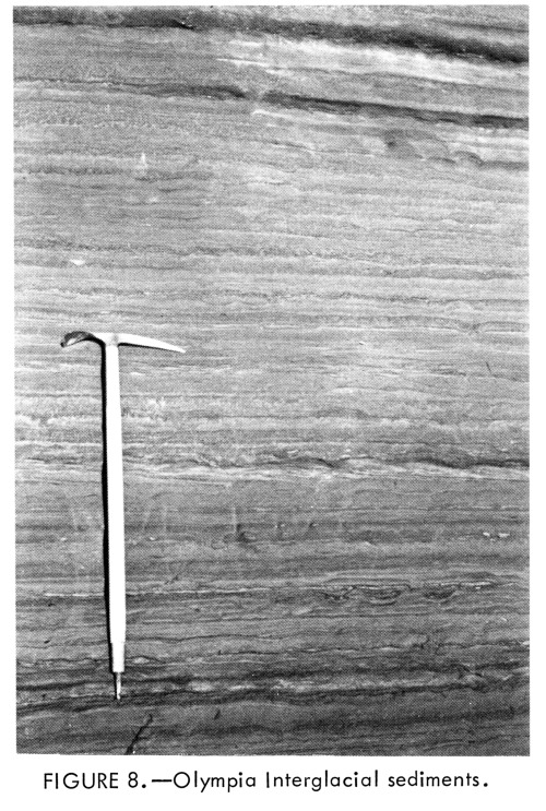
in which layers of clay, silt, and sand were deposited (Fig. 8).
In the higher parts of the Puget Sound lowland, this was a period of
weathering and erosion. In the Seattle area, a zone of weathered clay
has been recognized on one of the hills of older drift that stood
above the Olympia flood plain (Mullineaux and others, 1964).
Fossil pollen evidence indicates that the climate of the Puget Sound lowland was cooler and more moist than at present during the later part of the Olympia Interglaciation (Mullineaux and others, 1965). Alpine glaciers began to form and advance in the mountains of western Washington, and an ice sheet was developing in the mountains of western British Columbia. The alpine glaciers in western Washington soon retreated, but the ice sheet in the mountains of western British Columbia continued to expand into the lowlands of southwestern British Columbia and northwestern Washington. Thus began the main phase of the Fraser Glaciation, called the Vashon Stade (Armstrong and others, 1965).
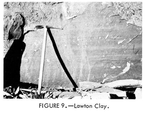
Approximately 15,000 years ago, a body of ice, called the Puget Lobe, pushed south into the Puget Sound lowland far enough to block the streams that had been flowing northward into the Strait of Juan de Fuca. This caused a large lake to form in the central part of the lowland, which drained southward into Grays Harbor by way of the lower Chehalis Valley. Water and sediment entered the lake from the glacier, which constituted its northern boundary, and also from the highlands on both sides. The coarser sediment carried by the water was dropped as streams entered the lake, while the silt- and clay-size particles settled to the bottom in the quieter water at some distance from the ice margin. A widespread deposit of clay and silt was thus created, which is called the Lawton Clay Member of the Vashon Drift (Mullineaux and others, 1965). The Lawton Clay (Fig. 9) is found throughout the axial portion of the Puget Sound lowland from north of Seattle to about the latitude of Tacoma.
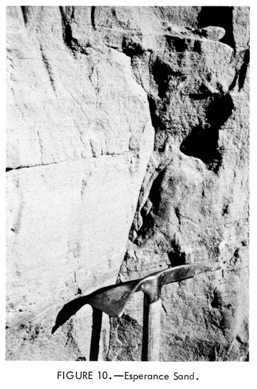
After the lake was mostly filled
with silt and clay, and as the glacier progressed farther south, a
thick layer of sand was deposited. This geologic unit, called the
Esperance Sand Member of the Vashon Drift (Fig. 10), spread over not
only the Lawton Clay but also the hills of older drift that were
protruding through the Lawton Clay.
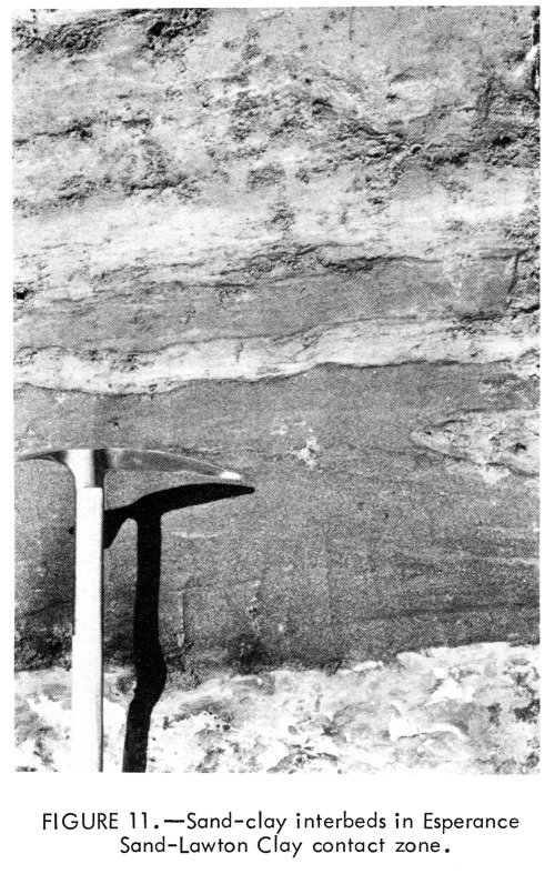
Where well exposed, the
transition between the Lawton Clay and the Esperance Sand is not
always a simple, abrupt change from clay and silt below to sand
above. Rather, there often exists a layer, up to several tens of feet
in thickness, in which alternating beds of sand and clay occur
(Fig. 11). In the formal stratigraphic literature this interval
has been arbitrarily assigned to the lower part of the Esperance Sand
(Mullineaux and others, 1965); however, it is more expedient for
mapping purposes to include the interval in the upper part of the
Lawton Clay (Fig. 12). This reassignment is also useful in
delineating a particular zone of high landslide hazard and in
describing the mechanisms of the landslides. In this report the
"Esperance Sand-Lawton Clay contact" refers to this
informally redefined boundary.
The Esperance Sand often becomes coarser and more pebbly near its top, grading into the coarser and more poorly sorted Vashon advance outwash--sands and gravels deposited directly in front of the advancing ice by glacial melt-water streams. In some places, the Vashon advance outwash was deposited in stream channels cut into the upper part of the Esperance Sand; there the change in character is more abrupt.
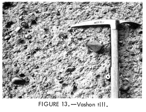
The Puget Lobe of the Vashon glacier advanced southward to a position about 15 miles beyond Olympia. At its maximum, the ice thickness in the vicinity of Seattle may have been over 4,000 feet. The ice, in moving over the unconsolidated sands and clays, scoured out the newly deposited material more readily than it did the older deposits. It thus eroded troughs where previously there had been valleys aligned parallel to the direction of ice movement, and left behind hills with cores of older sediments (Crandell and others, 1965).
Some of the material that the
glacier eroded was redeposited farther south as advance outwash. Much
of it, however, was incorporated into the Vashon till--a nonsorted,
nonstratified sediment deposited directly by the glacial ice
(Fig. 13). Most of the Vashon till is very compact, because it
was "plastered" onto the ground surface under the weight of
several thousand feet of ice. However, as the glacier finally began
to melt away, a less compact layer of till was left at the ground
surface as the residual debris from the thawing, dirty ice.
During the maximum extent of the glaciation, the Puget Lobe pushed up into the major valleys in the Cascade Mountains and created ice-marginal lakes (Mackin, 1941). Drainage of the western flank of the Cascades was accomplished via ice-marginal channels connecting these lakes and leading around the eastern and southern margins of the Puget Lobe, eventually reaching the Pacific at Grays Harbor.
The recession of the Puget Lobe was quite rapid. By approximately 13,500 years ago (Mullineaux and others, 1965) the ice had melted back to a latitude north of Seattle, and by 11,000 years ago the ice front had retreated up the Fraser River valley. As it retreated, a glacially sculptured landscape of uplands and intervening valleys was uncovered. In front of the melting ice, and coursing across the uplands, were melt-water streams that connected ice-dammed lakes in the valleys. These streams often cut large melt-water channels and, especially where they emptied into the lakes, locally deposited Vashon recessional outwash.
As the glaciers in various parts
of the world melted, sea level rose rapidly an marine water invaded
Puget Sound. Currents and wave action have since cut away at the base
of the glacially formed slopes, occasionally oversteepening the
slopes so that material slides down to the beach, where it is
subsequently removed by the waves and currents. Some material,
apparently less prone to sliding, may stand up as relatively steep
sea cliffs, although they too are undergoing slow retreat due to a
combination of erosional processes.
REFERENCES CITED
Armstrong, J.E.; Crandall, D.R.; Easterbrook, D.J.; Noble, J.B., 1965, Late Pleistocene stratigraphy and chronology in southwestern British Columbia and northwestern Washington: Geol. Soc. America Bull., v. 76, p. 321-330.
Crandell, D.R., 1965, The glacial history of western Washington and Oregon. In Wright, H.E., Jr.; Frey, D.G., editors, The Quaternary of the United States: Princeton, N.J., Princeton Univ. Press, 1965, p. 341-353.
Crandell, D.R.; Mullineaux, D.R.; Waldron, H.H., 1965, Age and origin of the Puget Sound Trough in western Washington: U.S. Geol. Survey Prof. Paper 525-B, p. B132-B136.
Easterbrook, D.J.; Crandell, D.R.; Leopold, E.B., 1967, Pre-Olympia Pleistocene stratigraphy and chronology in the central Puget Lowland, Washington: Geol. Soc. America Bull., v. 78, p. 13-20.
Liesch, B.A.; Price, C.E.; Walters, K.L., 1963, Geology and ground-water resources of northwestern King County, Washington; Washington Div. Water Resources Water Supply Bull. 20, 241 p.
Livingston, V.E., Jr., 1971, Geology and mineral resources of King County, Washington: Washington Div. Mines and Geology Bull. 63, 200 p.
Mackin, J.H., 1941, Glacial geology of the Snoqualmie-Cedar area, Washington: Jour. Geol., v. 49, p. 449-481.
Mackin, J.H., 1949, Engineering geology of West Seattle: Univ. of Washington The Trend in Engineering, v. 1, no. 3, p. 24-26.
Mackin, J.H.; Mullineaux, D.R.; Stark, W.J., 1950, Glacial geology of Seattle: Univ. of Washington The Trend in Engineering, v. 2, no. 4, p. 19-21.
Mullineaux, D.R.; Nichols, T.C.; Speirer, R.A., 1964, A zone of montmorillonitic weathered clay in Pleistocene deposits at Seattle, Washington: U.S. Geol. Survey Prof. Paper 501-D, p. D99-D103.
Mullineaux, D.R.; Waldron, H.H.; Rubin, Meyer, 1965, Stratigraphy and chronology of late interglacial and early Vashon glacial time in the Seattle area, Washington: U.S. Geol. Survey Bull. 1194-0, 10 p.
Waldron, H.H., 1967, Geologic map of the Duwamish Head quadrangle, King and Kitsap Counties, Washington: U.S. Geol. Survey Geol. Quad. Map GQ-706.
Waldron, H.H.; Liesch, B.A.; Mullineaux, D.R.; Crandell, D.R., 1962, Preliminary geologic map of Seattle and vicinity, Washington: U.S. Geol. Survey Miscellaneous Geol. Investigations Map I-354.